Get ready for record-breaking Arctic blast this week, if you think it's cold now
- HOME
- ENTERTAINMENT
- Get ready for record-breaking Arctic blast this week, if you think it's cold now
- Last update: 42 minutes ago
- 3 min read
- 326 Views
- ENTERTAINMENT
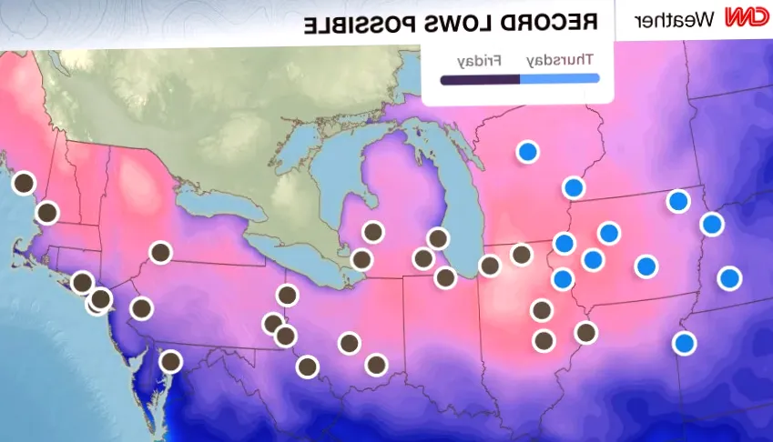
Temperatures are already low, but an incoming surge of Arctic air is expected to plunge the nation into extreme cold. Following the recent winter storm, over 200 million Americans will wake up to frigid conditions as the coldest air of the season moves through the Plains, Midwest, Great Lakes, and Northeast. This intense chill could break numerous daily temperature records.
The Midwest, after enduring multiple snowfalls last week, is now bracing for the harshest cold so far. Canadian Arctic air will descend into the Northern Plains and Upper Midwest by Wednesday. Highs are forecast to be 1525 degrees below normal, with parts of the Dakotas struggling to reach 10 degrees. Several cities in the Upper Midwest may record unprecedented daily high temperature lows.
Thursday morning is expected to be the coldest, with temperatures dropping well into the negatives in areas as far south as Iowa and Nebraska. Wind chills between -10 and -25 degrees will be widespread. Des Moines and Cedar Rapids, Iowa, could break daily low temperature records, hitting -11 and -7 degrees respectively. Cedar Rapids may remain in the single digits above zero in the afternoon, setting a new record for the coldest high of the day.
Afternoon temperatures across much of the Midwest are predicted to stay in the teens, 2030 degrees below typical early December levels. Record lows may also be challenged from Illinois to the East Coast on Friday. Chicago could dip below its daily low record of 4 degrees, while Indianapolis approaches its 8-degree record from 1886. In Pennsylvania, lows in the teens could shatter multiple city records. New York City could see its coldest morning since early March, with temperatures around 20 degrees and record lows possible at JFK and LaGuardia airports. Wind chills will make it feel even colder.
The Role of the Polar Vortex
The severe cold this week is largely linked to the polar vortex, which began shifting in late November. Normally, the polar vortex contains frigid air within the Arctic, but it recently weakened and moved southward, allowing Arctic air to flow into populated regions. This shift also produces a wavier jet stream, causing swings between warmer and colder weather.
When this cold air collides with milder conditions, storm activity can increase, according to meteorologists. Experts warn that December will continue to see rapid fluctuations between unseasonably mild days and bitter cold as weather systems move through. However, the polar vortex is not the sole driver of these extremes, meaning other atmospheric factors are also at play.
More Cold Ahead
Forecasts indicate another wave of Arctic air may arrive by mid-December. The polar vortex is expected to stretch further over North America, prolonging the cold spells. Although winter officially begins in a few weeks, these events signal that frigid conditions have already arrived early this season.
Author: Jackson Miller
Share

Madison Beer's Bra Video perfectly matches her Tracklist Reveal.
2 minutes ago 2 min read ENTERTAINMENT

Sesame Street’s Beignet Blanc Clip Gives Parents a Clever Reference to Knives Out
5 minutes ago 2 min read ENTERTAINMENT

School Spirits Season 3 to Premiere in January, Paramount+ Unveils Creepy First Glimpse
6 minutes ago 2 min read ENTERTAINMENT

Anne Hathaway's Social Media Post Becomes a Sensation
7 minutes ago 2 min read ENTERTAINMENT

Must See: Kim Kardashian Sitting in Mini-Dress
8 minutes ago 1 min read ENTERTAINMENT

Lisa Rinna's Husband Harry Hamlin Claims He Was Coerced into Smoking PCP in Jail
8 minutes ago 2 min read ENTERTAINMENT

Of course, kettlebells can help you gain muscle - here's the initial 3-move routine I recommend
9 minutes ago 2 min read ENTERTAINMENT

Children and cephalopods: Third graders overcome fears and explore science during squid dissection field trip
10 minutes ago 3 min read ENTERTAINMENT

Michael Douglas and Catherine Zeta-Jones Address CNN Boycott Rumors
12 minutes ago 2 min read ENTERTAINMENT

Los Angeles Times Journalists Approve New Guild Contract After 3 Years of Talks
14 minutes ago 2 min read ENTERTAINMENT