First-Ever Satellite Image Captures Tsunami Wave From Space (Video)
- Last update: 44 minutes ago
- 2 min read
- 120 Views
- WORLD
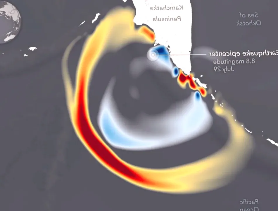
In late July, a powerful earthquake registering 8.8 on the Richter scale shook the Kamchatka Peninsula near Russia. Shortly after, tsunami alerts were issued across nearly all Pacific coastlines, putting communities on high alert. Fortunately, the resulting damage from both the quake and the tsunami was minimal.
Despite the limited destruction, the event offered scientists a unique opportunity to study tsunami behavior, track their movements, and enhance predictive models for future events. Remarkably, for the first time ever, a satellite was able to observe a tsunami directly from space, providing a completely new perspective on these destructive natural phenomena.
The Surface Water Ocean Topography (SWOT) satellite documented the tsunami generated by the Kamchatka earthquake on July 30. By collecting precise information on the waves height, shape, and trajectory, SWOT is helping researchers refine forecasting techniques and bolster coastal safety measures.
A study featuring SWOT data appeared in The Seismic Record, presenting detailed models of the wave created by the massive underwater seismic shift off Russias coast. Angel Ruiz-Angulo from the University of Iceland described the significance of the data, stating, SWOT provides a new lens. Previously, monitoring relied on DART buoys, which only offered isolated readings. Other satellites could capture narrow lines across a tsunami, at best. SWOT can now measure swaths up to 120 kilometers wide, delivering high-resolution observations of the sea surface.
NASA highlighted the importance of this advancement, noting that the new observational method could ultimately save lives. SWOT supplied a multidimensional view of the tsunamis leading edge from the Kamchatka quake. By capturing data on its height, shape, and direction, the satellite enables scientists to enhance forecast models and better protect coastal populations, NASA stated.
This milestone in satellite monitoring marks a major step forward in understanding and preparing for future tsunami events.
Author: Benjamin Carter
Share

Charles Shay, the teen medic who saved lives on D-Day, passes away at the age of 101
2 minutes ago 3 min read WORLD

18,000 Tracks Found in the Largest Dinosaur Tracksite in the World
3 minutes ago 2 min read WORLD

Continued heavy rain hinders recovery efforts as death toll from floods in Asia surpasses 1,750
9 minutes ago 2 min read WORLD

Ukraine detains British suspect accused of assisting Russia’s FSB in plot to assassinate
18 minutes ago 2 min read WORLD

Friend saves man in Christmas Day 'carnage'
19 minutes ago 2 min read WORLD

Memorable Family Traditions of Prince William and Princess Kate During the Holiday Season
19 minutes ago 4 min read WORLD

Former EU high-ranking diplomat being questioned in fraud investigation maintains his innocence
20 minutes ago 2 min read WORLD

Tractor light parade scheduled to spread Christmas joy
20 minutes ago 2 min read WORLD

How Kent managed to survive a week without access to water
21 minutes ago 2 min read WORLD

Drug dealer sentenced to jail after being on the run for months
22 minutes ago 2 min read WORLD