As the burst of cold air diminishes, frigid air is expected next week.
- HOME
- ENTERTAINMENT
- As the burst of cold air diminishes, frigid air is expected next week.
- Last update: 4 hours ago
- 3 min read
- 459 Views
- ENTERTAINMENT

This week's brief stretch of wintry cold is set to ease on Saturday, but a new surge of frigid air is anticipated for the coming week. While record-breaking chills are not expected this weekend and temperatures may feel slightly milder for a short time, the overall conditions will remain cold and windy across much of the country.
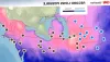
Wind Chill Outlook
Saturday afternoon wind chills could drop to the mid-20s in Chicago, the mid-30s in New York City, and the mid-40s in Washington D.C.
Light Snow Along the East Coast
During the overnight hours into Saturday morning, light snow and wintry precipitation briefly affected areas along the I-95 corridor from Washington D.C. to New York City. Most locations only received a dusting, with measurable snowfall reaching up to half an inch in spots from D.C. to western New Jersey. Icy and slick conditions may persist Saturday morning, but improvement is expected later in the day. Morning wind chills are slightly warmer compared to Friday morning, though still cold for the season.
Next Weeks Cold Blast
A stronger wave of cold air is forecast to return to the Midwest and Northeast by Monday, bringing high temperatures near freezing and lows around or below zero. Meanwhile, parts of the Western U.S. are expected to warm, with some locations approaching or surpassing daily record highs.
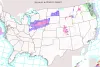
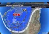
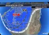
Snow in the Upper Midwest
A fast-moving snowstorm will sweep through the Dakotas and Nebraska on Saturday, reaching Wisconsin and Illinois by Sunday. Snow is expected to arrive in Iowa and Minnesota by early afternoon. The heaviest accumulations, between 3 to 7 inches, are forecast for Iowa and southern Minnesota. Winter Storm Warnings are in effect for Fort Dodge, Waterloo, Mason City, and Worthington. By evening, snowfall may begin in Chicago and Milwaukee, potentially totaling 3 to 4 inches, with higher amounts further west. Overall, at least 1 to 3 inches is expected from Montana and the Dakotas down to southern Wisconsin and northern Illinois.
Impact on the Northeast
As this system progresses eastward, it will bring another surge of cold air, though snowfall in the Northeast will mostly be limited to typical lake-effect snow.
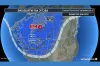
Rocky Mountain Snow
The Rockies, from Idaho and Montana down through Colorado and Utah, will continue to experience heavy snow through the weekend. Higher elevations could see over a foot of snow, with some areas receiving more than two feet. Snowfall is expected to taper off by Sunday morning. Winter Weather Advisories and Winter Storm Warnings remain active for these regions.
Author: Logan Reeves
Share
Get ready for record-breaking Arctic blast this week, if you think it's cold now
42 minutes ago 3 min read ENTERTAINMENT
Winter weather alerts will affect 18 million people in the West and Midwest.
1 hours ago 2 min read US
As the burst of cold air diminishes, frigid air is expected next week.
4 hours ago 3 min read ENTERTAINMENT
Arctic cold front sweeps through the Midwest and Northeast: Current weather forecast
8 hours ago 1 min read US
Cloudy Saturday followed by more snow on Sunday
12 hours ago 1 min read BUSINESS

Sub-zero temperatures grip central and northeastern US in Arctic blast
1 days ago 2 min read WORLD

View images of arctic cold wave affecting the Midwest and Northeast.
1 days ago 2 min read BUSINESS
Three polar vortices cause temperatures to drop in central and eastern U.S. as the first Arctic cold front arrives
1 days ago 3 min read WORLD
Three polar vortices cause temperatures to drop in central and eastern U.S. as initial Arctic cold front approaches
1 days ago 3 min read WORLD
Three polar vortexes will bring Arctic cold to central and eastern U.S. until mid-December.
1 days ago 3 min read WORLD